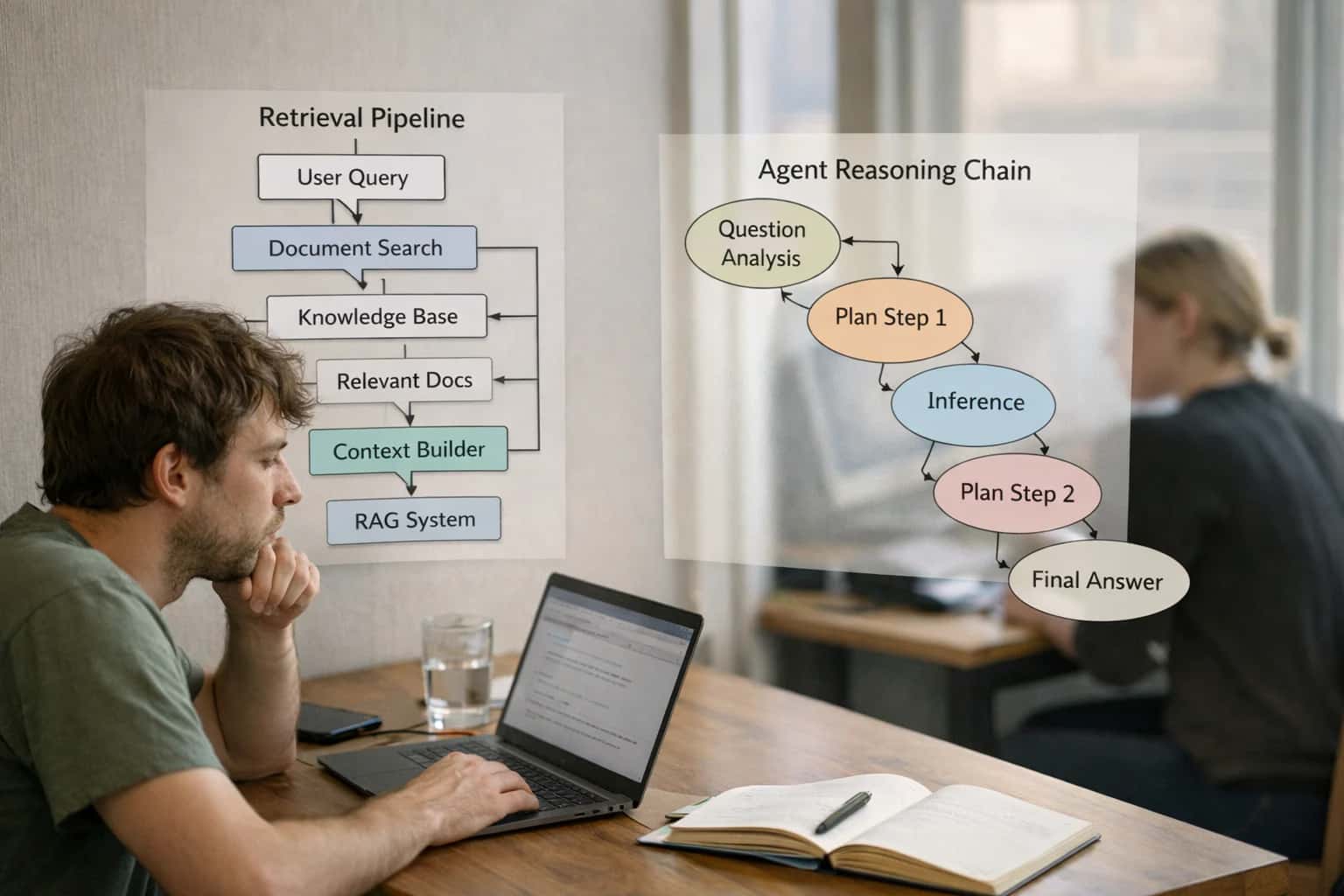
AI integration for government land management focuses on three primary system surfaces: Parcel and Land Records Systems, Permitting and Licensing Platforms (like Tyler EnerGov or Accela), and Computer-Assisted Mass Appraisal (CAMA) Systems. The integration connects AI agents to specific data objects—parcel IDs, permit applications, inspection reports, and property characteristic records—via APIs and webhooks. This enables use cases like automated title chain summarization from scanned deeds, initial completeness checks for subdivision applications, and generating draft valuation narratives by analyzing recent sales comparables and zoning changes.
Integration
AI Integration for Government Land Management
Implement AI agents to automate parcel research, assess property value trends, and manage right-of-way processes within Tyler EnerGov, SAP, and other government land systems.
ARCHITECTING AI FOR PARCEL, PERMIT, AND VALUATION WORKFLOWS
Where AI Fits into Government Land Management
A practical blueprint for integrating AI into core land management systems to automate research, accelerate permitting, and enhance valuation accuracy.
A production implementation typically uses a central orchestration layer (often on the agency's cloud) to manage AI workflows. For example, a new permit application in EnerGov triggers a webhook. An AI agent reviews the attached site plans and documents against the jurisdiction's checklist, flags missing items or potential code conflicts, and posts its findings back as a note in the permit record. For assessors, an agent can be scheduled to run nightly, analyzing new sales data and construction permits to flag parcels likely needing a value adjustment, creating a prioritized review queue in the CAMA system. Governance is critical; all AI-generated outputs should be clearly marked as "draft" or "for review," require human approval for final decisions, and maintain a full audit trail linking AI actions to specific users and records.
Rollout should be phased, starting with a single, high-volume, rules-based workflow like automated permit intake triage. This delivers quick wins (reducing planner review time from days to hours) and builds internal trust. Subsequent phases can tackle more complex tasks like interpreting zoning ordinances for setback verification or predicting right-of-way acquisition timelines. The goal isn't to replace planners or assessors but to eliminate the manual data gathering and initial analysis that consumes up to 70% of their time, allowing them to focus on high-judgment tasks and public service.
WHERE AI CONNECTS TO PARCEL, PERMIT, AND VALUATION WORKFLOWS
Primary Integration Surfaces in Land Management Systems
Core Data Hub for AI Integration
Land records systems are the primary system of record for parcel data, ownership history, easements, and zoning. AI integration surfaces here focus on automating research and data enrichment.
Key Integration Points:
- Parcel Search APIs: Connect AI agents to query ownership, tax ID, and legal description by address or parcel number.
- Document Attachment Fields: Use AI to classify and extract key terms from scanned deeds, plats, and title documents uploaded to parcel records.
- Transaction History Logs: Analyze sequences of sales and transfers to identify trends or flag irregular patterns for review.
Example Workflow: An AI agent triggered by a citizen inquiry can pull the full parcel history, summarize relevant restrictions, and draft a response—reducing research time from hours to minutes. Integration requires secure API calls to the land records database, often via REST endpoints or direct database connectors with appropriate RBAC.
OPERATIONAL AUTOMATION
High-Value AI Use Cases for Land Agencies
Integrate AI directly into land records, permitting, and valuation systems to automate manual research, accelerate decision cycles, and improve public service.
01
Automated Parcel Research & Title Summary
Connect AI agents to land records databases (e.g., CAMA, GIS, deed registries) to ingest and synthesize parcel history. Automatically generate summaries of ownership chain, easements, liens, and restrictions for staff review, turning hours of manual document review into minutes.
Hours -> Minutes
Research time
02
Predictive Property Valuation & Trend Analysis
Integrate AI models with Computer-Assisted Mass Appraisal (CAMA) systems to analyze sales comparables, zoning changes, and economic indicators. Flag parcels for potential reassessment, explain value anomalies, and generate narrative for appeals, improving assessment accuracy and fairness.
Batch -> Real-time
Trend monitoring
03
Right-of-Way & Easement Management Workflows
Build AI agents that monitor permit applications and capital project plans against easement and ROW databases. Automatically identify affected parcels, generate notification drafts for landowners, and populate required documentation into systems like Tyler EnerGov or Infor Public Sector.
1 sprint
Process setup
04
Intelligent Permit Application Triage & Review
Deploy AI to classify and route land-use permits (subdivisions, variances, site plans). Extract key data from submitted PDFs/plans, check for completeness against checklists, and flag applications needing specialist review, reducing backlog and applicant wait times.
Same day
Initial review
05
Constituent Q&A for Land Records & Zoning
Implement a secure chatbot integrated with authoritative zoning codes, ordinance databases, and public parcel viewers. Answer common public inquiries about setback rules, permitted uses, and assessment processes, deflecting calls from staff and providing 24/7 access.
06
Automated Compliance Monitoring for Land Use
Connect AI to code enforcement and planning systems to cross-reference permit approvals with satellite/aerial imagery. Automatically detect potential violations (e.g., unpermitted structures, clearing) and generate prioritized case lists for inspectors, optimizing field resources.
IMPLEMENTATION PATTERNS
Example AI-Powered Land Management Workflows
These workflows illustrate how AI agents and copilots can be integrated into core land management systems to automate research, accelerate permitting, and improve valuation accuracy. Each pattern connects to specific modules and data objects within platforms like Tyler EnerGov, SAP Public Sector, or specialized GIS and CAMA systems.
Trigger: A planner, attorney, or developer initiates a land use request or property acquisition search.
Context Pulled: The AI agent is triggered via API from the land management system's case module. It retrieves:
- Parcel ID and legal description from the Assessor's database.
- Current and historical ownership records from the Recorder's office.
- Existing permits, violations, and zoning designations from the Planning/Permitting system.
- Environmental constraints (wetlands, floodplains) from the GIS layer.
- Utility easements and right-of-way agreements from the Public Works asset management system.
Agent Action: A multi-step agent (e.g., using CrewAI or a custom orchestrator) queries each system, synthesizes the findings into a consolidated due diligence report, and highlights potential showstoppers (e.g., unresolved violations, restrictive easements).
System Update: The generated report is saved as a PDF back to the case file in the land management system, with key findings (parcel status, critical issues) written to structured fields for reporting.
Human Review Point: The report is flagged for review by a senior planner. The AI provides a confidence score; low-confidence findings (e.g., ambiguous legal descriptions) are explicitly called out for human verification.
FROM DATA SILOS TO INTELLIGENT WORKFLOWS
Implementation Architecture: Connecting AI to Land Systems
A practical blueprint for integrating AI into land records, permitting, and valuation systems to automate parcel research, assess property value trends, and manage right-of-way processes.
Integrating AI into government land management requires connecting to specific data objects and workflows within your core systems. This typically involves creating an orchestration layer that interacts with key APIs and modules: the Parcel/Cadastre module for ownership and boundary data, the Permitting & Licensing system for application and review workflows, the Assessment/Valuation engine for property characteristics and tax rolls, and the Right-of-Way/Easement registry for encumbrance tracking. The integration architecture focuses on extracting structured and unstructured data from these sources—such as PDF deeds, survey plats, inspection photos, and application narratives—to feed AI models for analysis and automation.
High-value implementation patterns include:
- Automated Parcel Research: An AI agent queries the cadastre and document management system, summarizing ownership history, liens, and zoning restrictions for a given parcel ID, reducing research from hours to minutes.
- Permit Application Triage & Completeness Check: NLP models review submitted permit packages against a digital checklist, flagging missing documents or non-compliant plan elements and routing incomplete applications back to the applicant via the citizen portal.
- Trend-Based Valuation Support: AI analyzes recent sales, neighborhood development permits, and economic indicators to surface properties with assessment values potentially misaligned with market trends, generating a review queue for appraisers.
- Right-of-Way Process Automation: Computer vision extracts data from engineering drawings and legal descriptions to populate easement records, while an AI workflow manages notification timelines for affected landowners based on integrated GIS data.
A production rollout follows a phased, governed approach. Start with a pilot on a single workflow, like automating the cover sheet data entry from subdivision plats into the land records system. Use a secure integration platform or custom middleware to handle authentication, API calls to your land system (e.g., Tyler EnerGov, SAP Real Estate), and logging. Implement a human-in-the-loop review step for all AI-generated outputs during initial deployment, with clear audit trails back to source documents. Governance is critical: establish data quality checks for source systems, define prompt templates for consistent analysis, and set up monitoring for model drift in valuation or classification tasks. This ensures the AI augments—rather than disrupts—the legally binding and highly regulated processes of land administration.
GOVERNMENT LAND MANAGEMENT
Code and Payload Examples for Common Integrations
Automating Deed and Plat Analysis
Integrating AI with land records systems (e.g., Tyler Content Manager, specialized CAMA systems) automates the extraction of key details from scanned deeds, plats, and historical documents. An AI agent can be triggered via a webhook when a new document is ingested into the records management system.
The agent uses a vision model to perform OCR and a language model to extract structured data—such as grantor/grantee names, legal descriptions, acreage, and easements—into a JSON payload. This payload is then posted back to update the parcel record in the core land management database, reducing manual data entry from hours to minutes per document.
python# Example: Webhook handler for document processing import json from land_management_sdk import ParcelAPI async def handle_new_document_webhook(document_url, parcel_id): """Process a new scanned deed or plat.""" # 1. Call vision/OCR service extracted_text = await ocr_service.extract_text(document_url) # 2. Use LLM to structure the data prompt = f"""Extract land record details from this text: {extracted_text} Return JSON with: grantor, grantee, legal_description, acreage, instrument_type.""" structured_data = await llm_service.extract_json(prompt) # 3. Update the parcel record payload = { "parcel_id": parcel_id, "source_document": document_url, "extracted_fields": structured_data } ParcelAPI.update(parcel_id, payload) return payload
AI FOR LAND MANAGEMENT WORKFLOWS
Realistic Time Savings and Operational Impact
How AI integration accelerates core land management processes by connecting to parcel records, permitting systems, and valuation models.
| Workflow | Before AI | After AI | Implementation Notes |
|---|---|---|---|
Parcel Research & Title Summary | 2-4 hours manual search across systems | Assisted draft in 15-20 minutes | AI retrieves and synthesizes deeds, liens, and easements from document management; planner reviews for accuracy |
Permit Application Intake & Completeness Check | Next-day manual review by staff | Automated checklist validation in real-time | AI scans uploaded plans and forms against code; flags missing items for applicant before submission |
Property Valuation Trend Analysis | Quarterly manual report compilation | Monthly automated dashboard with insights | AI analyzes recent sales, assessment data, and market indicators; highlights outliers for appraiser review |
Right-of-Way Document Processing | Manual extraction from scanned plats and deeds | Key data (width, conditions) pre-extracted | AI uses OCR and NLP on historical documents; creates structured records for GIS and asset management integration |
Public Inquiry on Zoning & Land Use | Email/phone response in 1-2 business days | Instant, accurate answers via chatbot | Chatbot grounded in zoning ordinances and parcel maps; escalates complex questions to staff with full context |
Environmental Review Preliminary Screening | Manual cross-reference of maps and regulations | AI-assisted overlay and flagging | AI checks parcel against wetland, habitat, and floodplain layers; generates initial constraints report for reviewer |
High-Volume Plat/Subdivision Review | Sequential review by multiple disciplines | Parallel AI-assisted analysis for common checks | AI pre-analyzes for lot size, road frontage, and utility easement compliance; reduces rework cycles |
ARCHITECTING FOR PUBLIC SECTOR COMPLIANCE
Governance, Security, and Phased Rollout
A secure, governed approach to deploying AI for land management workflows.
Integrating AI into land management systems like Tyler EnerGov, SAP Real Estate, or specialized CAMA (Computer-Assisted Mass Appraisal) platforms requires a security-first architecture. This means implementing AI agents that operate within a zero-trust data access model, where API calls to the core ERP are authenticated via service principals with strict, role-based permissions (e.g., read-only access to parcel records, write access for workflow status updates). All AI-generated outputs, such as valuation trend analyses or permit review summaries, should be logged to an immutable audit trail linked to the source transaction and user session for full transparency.
A phased rollout is critical for managing risk and building trust. Start with a read-only pilot focusing on a single, high-volume workflow, such as automating the initial data extraction and summarization of subdivision plat documents for planners. This allows validation of accuracy and performance without impacting live transactions. Subsequent phases can introduce attended automation, where an AI agent suggests permit review checklists or flags potential zoning conflicts for a human reviewer within the system's workflow engine before final approval. The final phase involves closed-loop automation for low-risk, repetitive tasks like generating standard response letters for routine zoning inquiries, fully integrated into the citizen portal.
Governance is established through a human-in-the-loop (HITL) framework and continuous model monitoring. For example, any AI-recommended property valuation adjustment exceeding a pre-defined threshold (e.g., 5%) must route through a supervisor approval workflow in the system. Drift detection monitors for degradation in the AI's performance on tasks like extracting legal descriptions from deeds, triggering alerts for model retraining. This controlled, incremental approach ensures the integration enhances efficiency while maintaining the strict compliance, data sovereignty, and public accountability required in government land management operations.
Enabling Efficiency, Speed & Accuracy
Intelligent Analysis, Decision & Execution
We build AI systems for teams that need search across company data, workflow automation across tools, or AI features inside products and internal software.
Talk to Us
Search across company data
Give teams answers from docs, tickets, runbooks, and product data with sources and permissions.
Useful when people spend too long searching or get different answers from different systems.
Enterprise searchRAGPermissions
Read more
Automate internal workflows
Use AI to route work, draft outputs, trigger actions, and keep approvals and logs in place.
Useful when repetitive work moves across multiple tools and teams.
AI agentsWorkflow automationGovernance
Read more
Add AI to products and internal tools
Build assistants, guided actions, or decision support into the software your team or customers already use.
Useful when AI needs to be part of the product, not a separate tool.
AI integrationDecision supportModel routing
Read moreIMPLEMENTATION QUESTIONS
FAQ: AI Integration for Land Management
Practical questions and answers for government IT, GIS, and land management teams planning to integrate AI into Tyler EnerGov, SAP Public Sector, or custom land records systems.
Direct database connections are a security and compliance risk. The standard pattern is to build a secure API layer.
Typical Architecture:
- API Gateway: Expose read-only endpoints (e.g.,
/parcels/{id},/permits/search) from your core land management system (e.g., Tyler EnerGov, SAP Real Estate). - Orchestration Service: A middleware service (often on BTP, Infor OS, or a secure cloud) calls these APIs and the AI model.
- AI Tool Calling: The agent uses function calling to request specific data. The orchestration service executes the query, filters/redacts sensitive data (e.g., SSNs), and returns only the necessary context.
- Audit Log: All queries, the data retrieved, and the AI's response are logged for compliance (e.g., public records requests).
Example Payload to Internal API:
json{ "action": "get_parcel_details", "parameters": { "parcel_id": "19-001-234", "fields": ["owner_name", "zoning", "last_sale_date", "assessed_value"] } }
This ensures the AI only accesses data through governed, auditable pathways.

About the author
Prasad Kumkar
CEO & MD, Inference Systems
Prasad Kumkar is the CEO & MD of Inference Systems and writes about AI systems architecture, LLM infrastructure, model serving, evaluation, and production deployment. Over 5+ years, he has worked across computer vision models, L5 autonomous vehicle systems, and LLM research, with a focus on taking complex AI ideas into real-world engineering systems.
His work and writing cover AI systems, large language models, AI agents, multimodal systems, autonomous systems, inference optimization, RAG, evaluation, and production AI engineering.
LinkedIn
Limited slotsGet a Free AI Consultation
Partnered with leading AI, data, and software stack.


How We Work
Custom AI workflows for your Business
One-fit-all AI don't work for modern businesses. At Inferensys, we aim to understand your business & custom requirements; which we use to define most efficient agentic workflows, the data, and the tools for your business.
01
Review the use case
We understand the task, the users, and where AI can actually help.
Read more02
Pick the right approach
We define what needs search, automation, or product integration.
Read more03
Build the first useful version
We implement the part that proves the value first.
Read more04
Improve from there
We add the checks and visibility needed to keep it useful.
Read moreThe first call is a practical review of your use case and the right next step.
Talk to Us