Traditional geospatial intelligence relies on analysts manually scanning thousands of satellite images—a process that is painfully slow, impossible to scale, and vulnerable to oversight. Key objects and subtle changes are easily missed, leading to delayed decisions and operational risk.
Service
Geospatial Computer Vision for Object Detection
Specialized development and deployment of computer vision models trained on aerial and satellite imagery to identify and track objects with high precision for security and logistics applications.
INEFFICIENCY AT SCALE
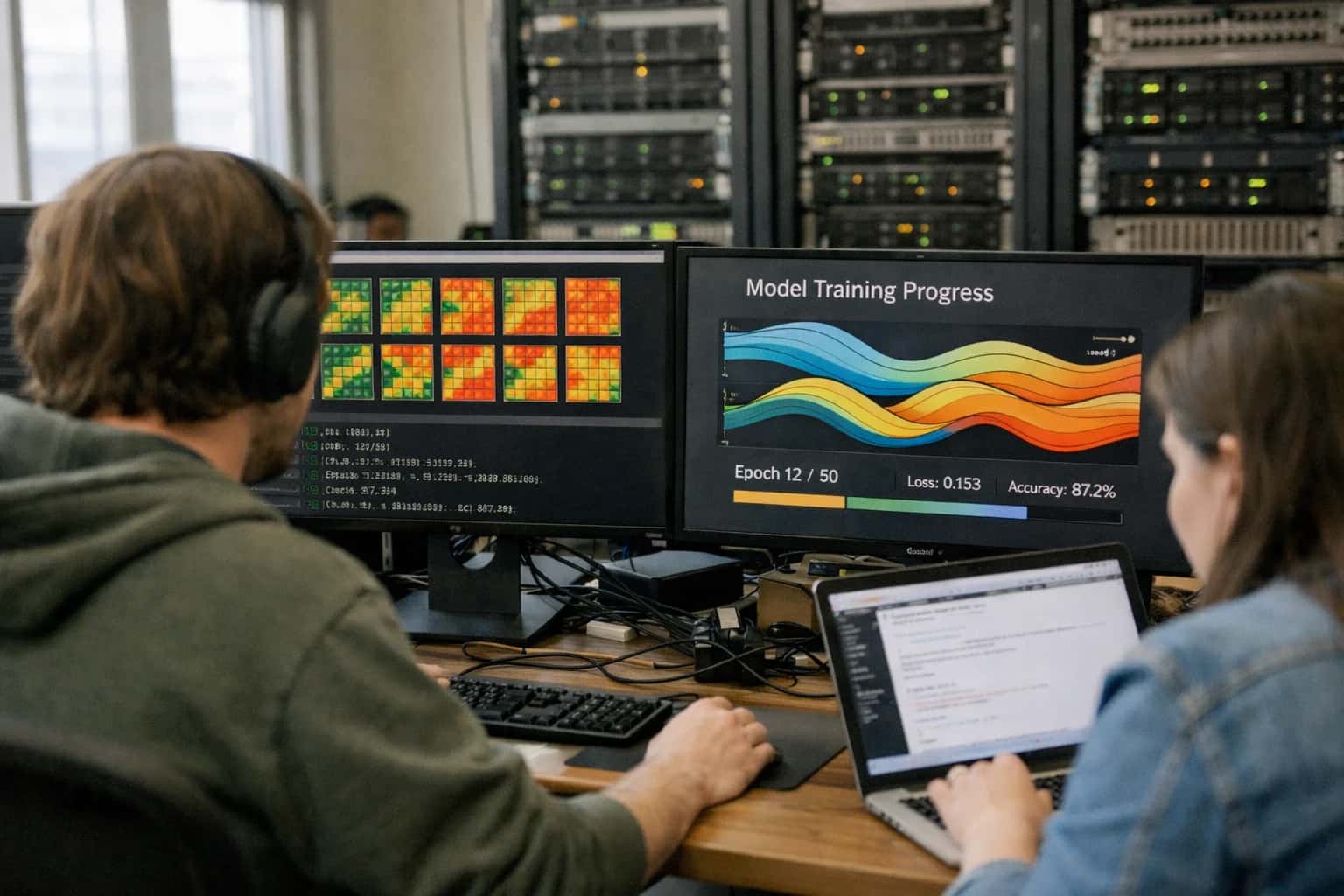
The Challenge of Manual Geospatial Analysis
Manual satellite image analysis is slow, costly, and prone to human error, creating critical intelligence gaps.
Our geospatial computer vision service automates this process, delivering 99%+ detection accuracy for objects like vehicles, ships, and infrastructure at planetary scale, turning imagery into actionable intelligence in minutes, not months.
- High Latency, Low Throughput: Manual review of a single high-resolution satellite scene can take hours. Our AI pipelines process petabytes of imagery from constellations like Sentinel and Landsat in parallel.
- Inconsistent & Error-Prone: Human fatigue leads to inconsistent labeling and missed detections. Our custom-trained models (e.g., YOLO, Detectron2) provide deterministic, repeatable analysis.
- Sky-High Operational Costs: Scaling a team of expert analysts is prohibitively expensive. Automate detection and tracking to reduce analysis costs by over 70% while freeing your team for high-value strategic work.
For enterprises requiring real-time situational awareness, this manual bottleneck is a critical vulnerability. Explore our approach to planetary-scale satellite imagery AI processing or learn how we build Geospatial RAG Systems for accurate, sourced intelligence reporting.
DELIVERABLE IMPACT
Business Outcomes You Can Measure
Our geospatial computer vision solutions translate directly into measurable operational improvements and cost savings. We focus on delivering specific, quantifiable results for national security, logistics, and infrastructure monitoring.
02
Reduced Operational Latency
Implement edge AI deployment on drones and field devices to cut analysis latency from hours to seconds, delivering real-time intelligence for rapid decision-making in disaster response and dynamic security scenarios.
< 2 sec
Analysis Latency
Offline
Operational Capability
04
Infrastructure Risk Mitigation
Utilize time-series geospatial AI to predict failures in pipelines, power lines, and railways weeks in advance, shifting from reactive to prognostic maintenance to prevent costly downtime and safety incidents.
> 80%
Accuracy in Failure Prediction
Weeks
Advanced Warning
06
Compliant & Secure Deployment
Ensure all data processing and model training adheres to sovereign data mandates and security protocols. Our architectures are designed for air-gapped or hybrid-cloud environments, meeting defense and enterprise compliance standards.
Air-Gapped
Deployment Option
ISO 27001
Security Framework
Clear, Predictable Outcomes
Typical Project Timeline and Deliverables
A structured breakdown of our engagement phases for developing and deploying a custom geospatial computer vision system, from initial model design to production integration.
| Phase & Deliverables | Timeline | Key Outcomes |
|---|---|---|
Phase 1: Discovery & Data Strategy | 1-2 Weeks | Technical requirements document, annotated data sample strategy, and architecture blueprint. |
Phase 2: Model Development & Training | 3-5 Weeks | Custom-trained object detection model (e.g., YOLOv8, Detectron2) with validated performance metrics on test set. |
Phase 3: Deployment & Integration | 2-3 Weeks | Production-ready API endpoint or containerized model integrated with your GIS platform (e.g., ArcGIS) or edge device. |
Phase 4: Performance Optimization & Scaling | 1-2 Weeks | Optimized inference latency (<100ms per tile), scalability plan, and operational runbook. |
Ongoing Support & MLOps | Optional SLA | Model monitoring, periodic retraining on new data, and 99.9% uptime guarantee. |
Total Project Duration | 7-12 Weeks | Fully operational, high-precision object detection system for aerial and satellite imagery. |
Enabling Efficiency, Speed & Accuracy
Intelligent Analysis, Decision & Execution
We build AI systems for teams that need search across company data, workflow automation across tools, or AI features inside products and internal software.
Talk to Us
Search across company data
Give teams answers from docs, tickets, runbooks, and product data with sources and permissions.
Useful when people spend too long searching or get different answers from different systems.
Enterprise searchRAGPermissions
Read more
Automate internal workflows
Use AI to route work, draft outputs, trigger actions, and keep approvals and logs in place.
Useful when repetitive work moves across multiple tools and teams.
AI agentsWorkflow automationGovernance
Read more
Add AI to products and internal tools
Build assistants, guided actions, or decision support into the software your team or customers already use.
Useful when AI needs to be part of the product, not a separate tool.
AI integrationDecision supportModel routing
Read moreGeospatial Computer Vision
Frequently Asked Questions
Get specific answers about our object detection service for satellite and aerial imagery, from timelines and costs to security and support.
Standard deployments for a production-ready object detection model (e.g., vehicle tracking) take 2-4 weeks. Complex, multi-class detection across diverse geographies or integration with existing systems like ArcGIS may extend to 6-8 weeks. We provide a detailed project plan with milestones after the initial discovery phase.

About the author
Prasad Kumkar
CEO & MD, Inference Systems
Prasad Kumkar is the CEO & MD of Inference Systems and writes about AI systems architecture, LLM infrastructure, model serving, evaluation, and production deployment. Over 5+ years, he has worked across computer vision models, L5 autonomous vehicle systems, and LLM research, with a focus on taking complex AI ideas into real-world engineering systems.
His work and writing cover AI systems, large language models, AI agents, multimodal systems, autonomous systems, inference optimization, RAG, evaluation, and production AI engineering.
LinkedIn
Limited slotsGet a Free AI Consultation
Partnered with leading AI, data, and software stack.


How We Work
Custom AI workflows for your Business
One-fit-all AI don't work for modern businesses. At Inferensys, we aim to understand your business & custom requirements; which we use to define most efficient agentic workflows, the data, and the tools for your business.
01
Review the use case
We understand the task, the users, and where AI can actually help.
Read more02
Pick the right approach
We define what needs search, automation, or product integration.
Read more03
Build the first useful version
We implement the part that proves the value first.
Read more04
Improve from there
We add the checks and visibility needed to keep it useful.
Read moreThe first call is a practical review of your use case and the right next step.
Talk to Us